Map and Directions
March 2025
New Version of Our Map of the Monument!
At Meet the Monument 2025 we handed out our latest version of the Monument map. As with the previous version, the major roads have the associated ID number listed on them. These will match with the road signage that is scheduled to be put up in the Monument. This version has a new cover photo of Ragged Top and our 25th anniversary logo. If you have any feedback about the map, please email us.

click on the above image for a full-size PDF version of the brochure
Map only
One of the most common requests we receive is for a map that helps people understand the extent and location of Ironwood Forest National Monument. While many people want a trail map, unlike nearby national parks, there are no signed trails in Ironwood Forest. It is a “primitive” monument that offers thousands of acres for exploration.
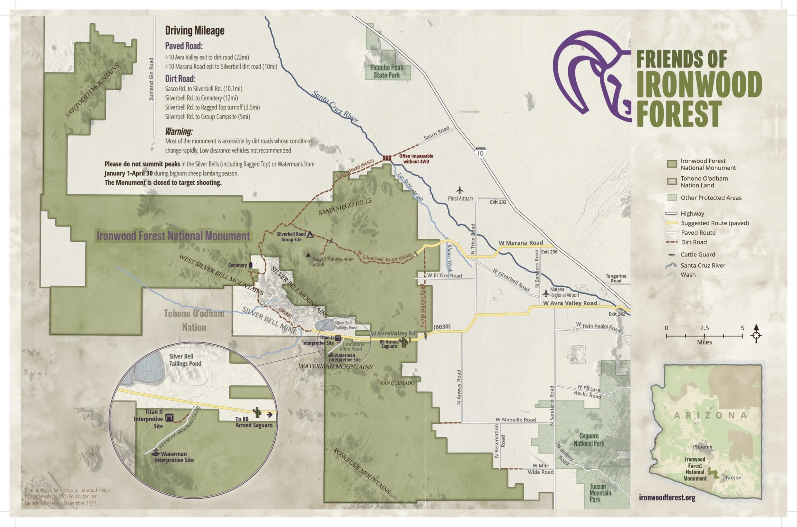
click on the above map image to see a larger version of just the map
click HERE to download a full size PDF of the map that you can print
There are a number of ways to access the IFNM:
Taking Avra Valley Road – Silverbell loop gives visitors a great introduction to the beauty of the monument. Exit the I-10 Interstate at the Avra Valley Road exit and head West. Turn North on Pump Station Road, this road is a dirt road but for most of the year is easily traveled with any high clearance vehicle, at Silverbell Road turn back to the West. This route will lead you through the IFNM to a beautiful view of Ragged Top Mountain and around the back side of the Silver Bell Mountains. The loop rejoins Avra Valley Road and will take you right back out to Interstate 10.
From I-10, take Exit 236 (Marana), head West towards the Circle K, taking Marana Road heading west. This road turns into Trico-Marana Road. Continue heading West until reaching Silverbell Road. Turn right on Silverbell Road. This road leads to the Monument and to the most popular area – the base of Ragged Top Mountain. If you turn south at the junction with Sasco Road, you will go around the Silverbell Mountiains and the Silverbell Road will turn into Avra Valley Road.
Taking Sasco Road from the Red Rock exit off I-10, proceed west to the sign and turn left on to Silverbell Road. You can either follow Silverbell Road back to the freeway or take Pump Station to Avra Valley Road and return to the Interstate that way. The Santa Cruz River crossing at Sasco Road is often closed and travelers should check road conditions with the Bureau of Land Management when planning to use this road.
Be a responsible monument visitor
We need your help to ensure that the Ironwood Forest National Monument remains the stunning place it is today. Respect the land, wildlife and other visitors, tread lightly and leave no trace. If you see something that shouldn’t be happening, please let us know and report the incident to the BLM at 1-800-309-7081
During both winter and summer rains some of the roads become impassable. Always obey road closed signs on the monument. Cell coverage is very spotty on the IFNM and tow service is difficult to come by if you get stuck!